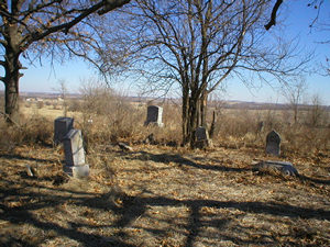
McBrien Cemetery
AKA Best Cemetery
Benton Township, Section 21
Andrew County, Missouri
 Directions: From State Route E, north on SR C 8.0 miles to 48 highway. West
on Highway 48 2.0 miles to County Road 136. North on 136 for 2.0 miles to pasture
gate on west side of road. West through pasture for 0.3 miles to cemetery on the
north of the fence line. There is no gate here, but there is a large hole in the
fence at the very east end where one can crawl under and into the cemetery. This
pasture is not on the cemetery land.
Directions: From State Route E, north on SR C 8.0 miles to 48 highway. West
on Highway 48 2.0 miles to County Road 136. North on 136 for 2.0 miles to pasture
gate on west side of road. West through pasture for 0.3 miles to cemetery on the
north of the fence line. There is no gate here, but there is a large hole in the
fence at the very east end where one can crawl under and into the cemetery. This
pasture is not on the cemetery land.
These pictures were taken by Nadine Taylor and Betty Halvorsen, 2006. ©THE Transcriptions
(Taylor, Halvorsen, Eshelman).
Row
Beginning at NW Corner |
Direction of Row |
Photograph(s) |
|
1
|
north to south
|
008-018
|
|
2
|
south to north
|
019-024
|
|
3
|
north to south
|
025-033, 035, 036
|
|
4
|
south to north
|
037-047
|
|
5
|
north to south
|
049-079
|
|
6
|
south to north
|
080-090, 130, 091, 034, 092-107
|
|
7
|
north to south
|
108-129, 166, 131-138, 148, 139-144,
153, 146, 147, 149-154
|
|
8
|
south to north
|
156-168
|
|
9
|
north to south
|
169-214
|
[Return to Top]