Union Grove Cemetery
Empire Township, Section 17
Andrew County, Missouri
 Directions: From Savannah, east on E Highway 3.5 miles. North on D about
5 miles. This cemetery is located on the west property line of a private farm and
can be accessed only by crossing that property with permission from property owner
or by driving on Conservation Department land, which requires a special permit and
can only be done in dry weather, as the road is a grass and mud trail with dangerous
hills.
Directions: From Savannah, east on E Highway 3.5 miles. North on D about
5 miles. This cemetery is located on the west property line of a private farm and
can be accessed only by crossing that property with permission from property owner
or by driving on Conservation Department land, which requires a special permit and
can only be done in dry weather, as the road is a grass and mud trail with dangerous
hills.
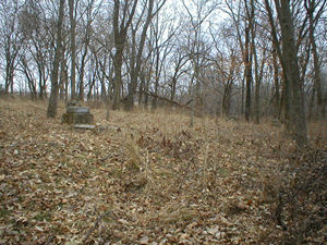
Note: The cemetery was apparently cleaned in 2003 by a Scout troop, but has been
neglected since then.
This cemetery was documented and photographed by Nadine Taylor and Betty Halvorsen,
2006. ©THE Transcriptions (Taylor, Halvorsen, Eshelman).
Row
Beginning in NW Corner |
Direction of Row |
Photograph(s) |
|
1
|
north to south
|
001-037
|
|
2
|
south to north
|
038-053
|
|
3
|
north to south
|
054-056
|
|
4
|
south to north
|
057-060, 136, 061-066, 069-077
|
|
5
|
north to south
|
078-094
|
|
6
|
south to north
|
095-115
|
|
7
|
north to south
|
118-130, 141-144, 131-134
|
|
Outside of main cemetery, on west edge, in brush
|
|
067, 068
|
[Return to Top]