|
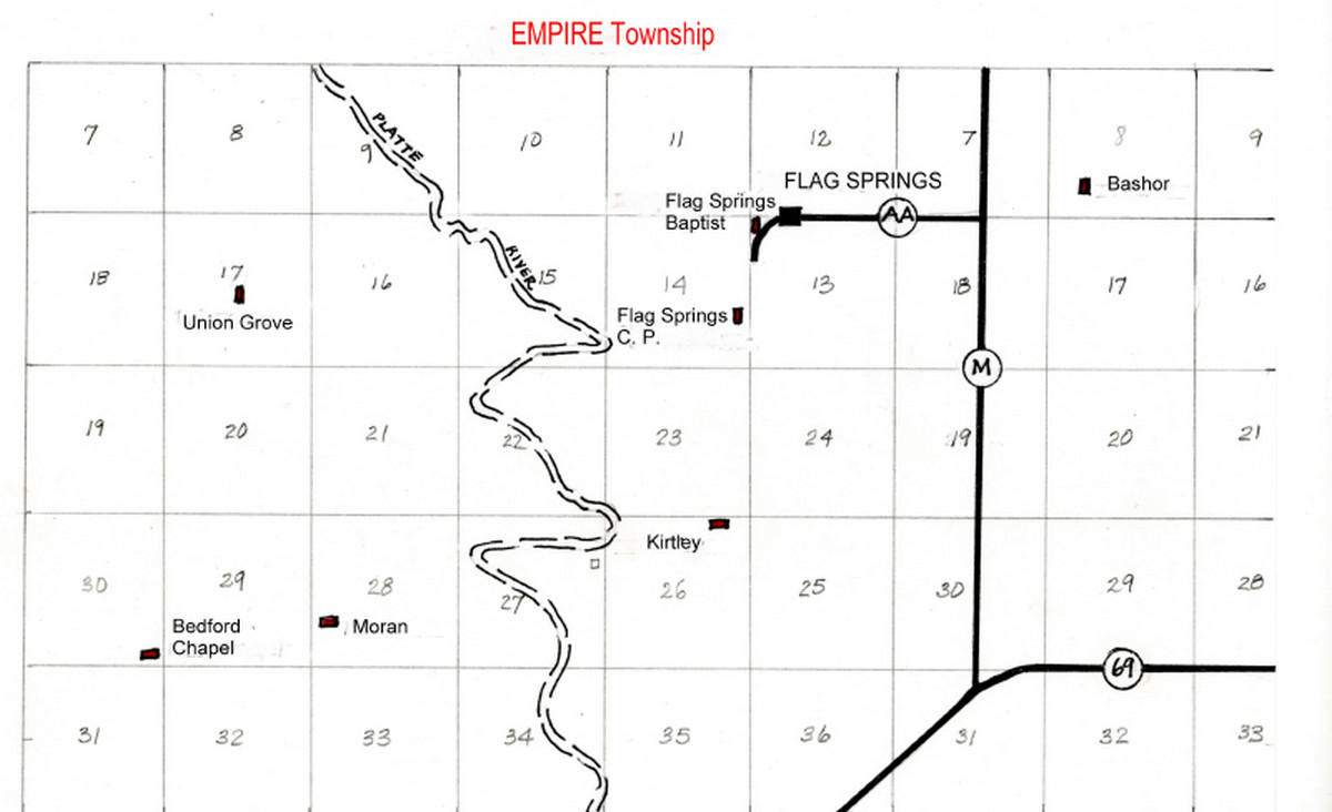
Bedford Chapel CemeteryEmpire Township, Section 30 WestAndrew County, Missouri
Directions: From Savannah US Business 71, east on State Route E 3.5 miles to SR D, then north and east 0.8 miles to County Road 185, then north 2.6 miles on CR 185 to CR 188. Cemetery is on the northwest corner of intersection. There is a grass driveway north of the intersection.
Notes: Bedford Chapel Church was established in the late 1860s.
Credits: These pictures were taken by Betty Halvorsen, 2005 & 2006. (c)THE Transcriptions (Taylor, Halvorsen, Eshelman).
These pictures were taken by Betty Halvorsen, 2005 & 2006. ©THE Transcriptions (Taylor, Halvorsen, Eshelman). * Indicates African-Americans + Indicates obituary available
Updates, corrections and additions: . . . [Yes! There’s more!]
Bashor CemeteryEmpire Township, Section 8 EastAndrew County, Missouri
Directions: North off US 169 on State Route M 3.1 miles to State Highway AA and County Road 229 intersection, then 0.8 mile east on CR 229 to driveway leading to private farm. Cemetery is north of CR 229 about 0.3 mile on farm fence line. Visitors must have landowner’s permission to visit site. Gates are electronically controlled by owner; there may be cattle in both pastures.
Credits: These pictures were taken by Betty Halvorsen, 2006. (c)THE Transcriptions (Taylor, Halvorsen, Eshelman).
Updates, corrections and additions: Castro, Martin Van Buren (1842-1865) Morrison, Sarah ( __ – __ ) . . . [Yes! There’s more!]
Antioch Christian Church Cemetery AKA Lambright Cemetery, Frazee Cemetery Clay Township, Section 18 Andrew County, Missouri
Directions: From Savannah north on US 71, 10.5 miles to State Route Y, then west 6.5 miles to County Road 7, south 0.5 mile to CR 6, from Fillmore north of SR H, which joins SR Y. Take SR Y northwesterly 6 miles to CR 7, then south on CR 7, 0.5 mile to CR 6. There are signs leading to the cemetery. The cemetery is on the south side of CR 6. It is neat and well-maintained.
Notes: AKA Lambright Cemetery or Frazee Cemetery
Credits: These pictures were taken by Joe and Keith Stanton and Betty Halvorsen 2005. (c)THE Transcriptions (Taylor, Halvorsen, Eshelman).
Updates, corrections and additions: (Edwards), Imo I. (1910-1997) Edwards, Charles . . . [Yes! There’s more!]
Maps included here are not meant to be stellar cartography. My map-making skills are slim. These maps, however, should give the viewer a closer idea of the locations of Andrew County townships, and the cemeteries within the townships. In order to drive to a particular cemetery, please consult the directions at the individual cemetery page. In a few instances, private property owners would prefer limited access to a particular cemetery; in which case, our directions are purposefully vague.
Keep in mind that the township boundaries have changed over the years. A cemetery may have been in one township years ago and now will appear in a different township. This can be confusing (even to PACT volunteers), so pay more attention to the section number than to the name of the township.
#gallery-1 { margin: auto; } #gallery-1 .gallery-item { float: left; margin-top: 10px; text-align: center; width: 33%;
}
#gallery-1 img {
border: 2px solid #cfcfcf;
}
#gallery-1 .gallery-caption {
margin-left: 0;
}
/* see gallery_shortcode() in wp-includes/media.php */
Rochester Township
Platte Township
Nodaway Township
Monroe Township
Lincoln Township
Jefferson Township
Jackson Township
Empire Township
Clay Township
Benton Township
|
|